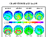
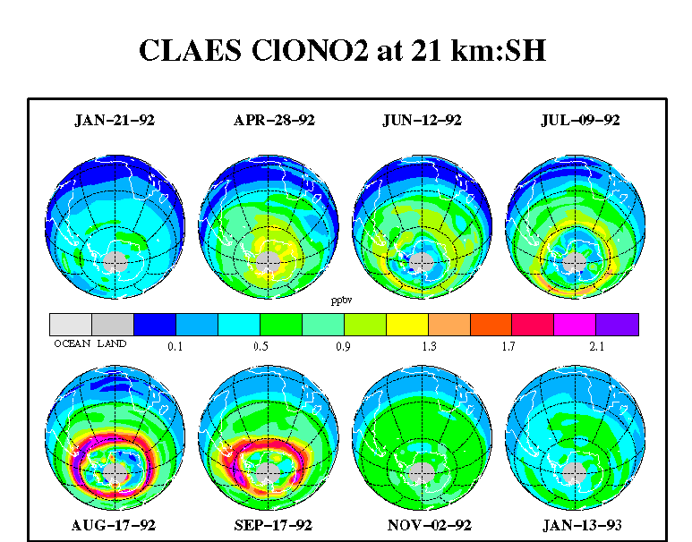
CLAES_CLONO2_S8
Polar orthographic projections of 24 hours of ClONO2 data at 21 km
as measured by CLAES in the Antarctic stratosphere for individual days
between January 1992 and January 1993. These days emphasize the
southern winter vortex region and the band or collar of increased
ClONO2 around it. [Similar to figures and discussion in "Observations
of Lower-Stratospheric ClONO2, HNO3, and Aerosol by the UARS CLAES
Experiment between January 1992 and April 1993", by Roche et al., J.
Atmos. Sci., 51, 2877-2902, Oct. 15, 1994.] |
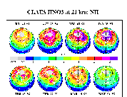
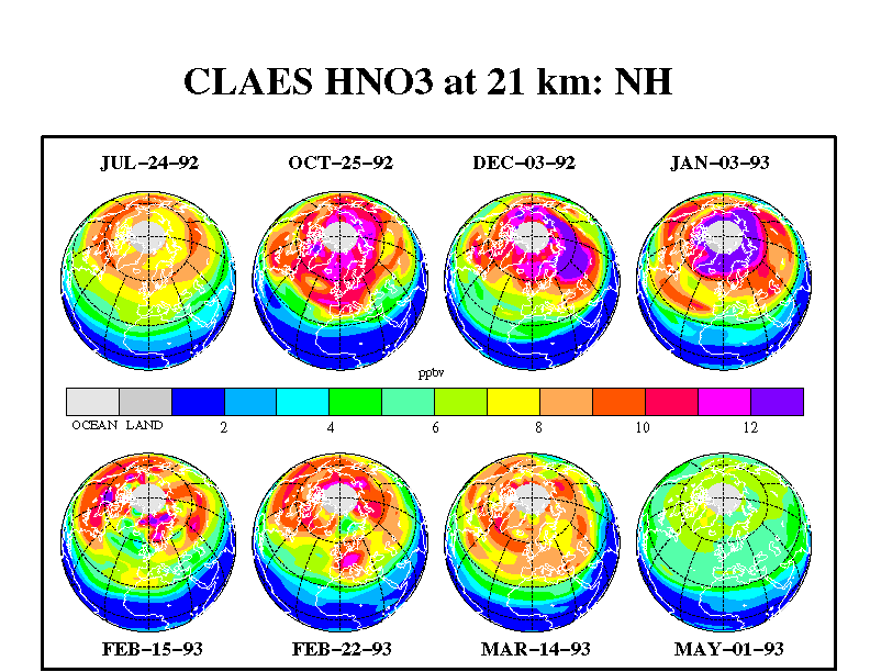
CLAES_HNO3_N8
Polar orthographic projections of 24 hours of HNO3 data at 21 km
as measured by CLAES in the Arctic stratosphere for individual days
between July 1992 and May 1993. These days emphasize the northern
winter vortex region and the depletion of HNO3 therein. [Similar to
figures and discussion in "Observations of Lower-Stratospheric ClONO2,
HNO3, and Aerosol by the UARS CLAES Experiment between January 1992
and April 1993", by Roche et al., J. Atmos. Sci., 51, 2877-2902,
Oct. 15, 1994.]
|
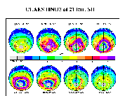
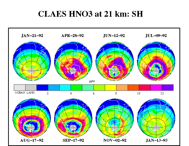
CLAES_HNO3_S8
Polar orthographic projections of 24 hours of HNO3 data at 21 km
as measured by CLAES in the Antarctic stratosphere for individual days
between January 1992 and January 1993. These days emphasize the
southern winter vortex region and the band or collar of increased
HNO3 around it. [Similar to figures and discussion in "Observations
of Lower-Stratospheric ClONO2, HNO3, and Aerosol by the UARS CLAES
Experiment between January 1992 and April 1993", by Roche et al., J.
Atmos. Sci., 51, 2877-2902, Oct. 15, 1994.]
|
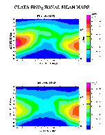
CLAES_HNO3_ZM2_MAPS_MAR
The CLAES HNO3 zonal-mean maps for March 1992 and March 1993 show a
distinct downward trend from year to year at tropical and southern mid
latitudes and a smaller trend at northern mid latitudes. This trend is
assumed to be due to the decreasing importance of the heterogeneous
hydrolysis of N2O5 on the sulfate aerosol as the Mt. Pinatubo aerosol
loading drops off.
|
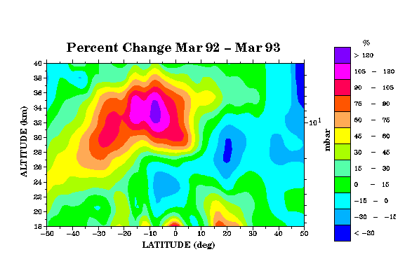
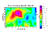 CLAES_HNO3_ZM_DIF_MAP_MAR
The percent change in CLAES zonal-mean HNO3 for March 1992 and March
1993 is presented and shows a distinct downward trend from year to year
at tropical and southern mid latitudes and a smaller trend at northern
mid latitudes. This trend is assumed to be due to the decreasing
importance of the heterogeneous hydrolysis of N2O5 on the sulfate
aerosol as the Mt. Pinatubo aerosol loading drops off
|
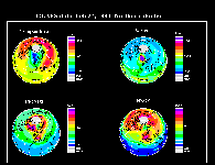
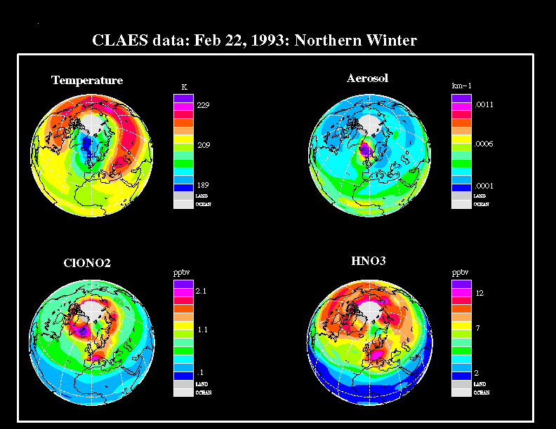
CLAES_N4_MIX_INVB
Polar projections at 21 km are shown for the CLAES temperature, aerosol,
ClONO2, and HNO3 data during the northern hemispheric winter on
February 22, 1993. Both the ClONO2 and HNO3 fields have assumed a
structure characterized by a partial band or collar region of high
values outside the vortex edge, as defined by the steepest temperature
gradient, which surrounded the coldest temperatures (below 189 K,
mainly over eastern Greenland or between Greenland and Scandinavia).
Aerosol extinction at high levels was seen on this day inside the
vortex region along with high volume mixing ratios of ClONO2 and a
depletion of HNO3. [For more information see Figures 15-19 and their
discussion in "Observations of Lower-Stratospheric ClONO2, HNO3, and
Aerosol by the UARS CLAES Experiment between January 1992 and April
1993", by Roche et al., J. Atmos. Sci., 51, 2877-2902, Oct. 15, 1994.]
|
